
Cochise County has hiking trails galore!
Cochise County is a paradise for the lover of all things outdoors.
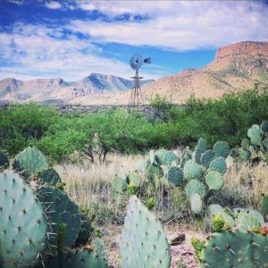 If you enjoy outdoor activities, Cochise County has loads of sunshine, miles of hiking trails, expanses of open range, and beautiful sky islands.
In addition, birds migrate through its outdoor recreation.


Cochise County offers state and national parks, national forest service stops, and national wildlife refuges. The county’s incredible outdoors is calling!

ARIZONA TRAIL
The Arizona National Scenic Trail is a rugged trail that is more than 800 miles long.
It starts at the Mexican border and goes north to the border of Utah. The first 21 miles are in the Huachuca Mountains in Sierra Vista.

CHIRICAHUA MONUMENT
With 15 trail combinations, the Chiricahua National Monument offers hours of outdoor recreation. See the Trail Guide for more information on hiking in the “Land of the Standing up Rocks.”
You can also hike 1.5 miles into Fort Bowie, now a national historic site. It was the site of the Bascom Affair, which sparked the Indian Wars. Interpretive signs along the hike tell about the graveyard, a natural spring, and the Butterfield Overland Stage. Fort Bowie’s adobe remains are still visible at the trail’s end, where a visitor center is located.

CHIRICAHUA MOUNTAINS
You’ll find Silver Peak Trail in the Chiricahua Mountains. Access this trail from the town of Portal.
The Chiricahua Mountains are the largest of Arizona’s Sky Island mountain ranges and the second highest. The main crest of the mountain range resembles rolling hills atop a narrow high plateau rather than distinct mountain peaks.

COCHISE STRONGHOLD
Cochise Stronghold is a collection of granite boulders in the Dragoon Mountains that Apache leader Cochise and his men used as a natural fortress.
Take the 4.5 mile Cochise Stronghold hike over the Stronghold Divide to meet the West Stronghold Canyon trailhead. The hike is moderately strenuous. For more information, consult the Douglas Ranger district of the Coronado National Forest.

HUACHUCA MOUNTAINS
Trails in the Huachuca Mountains include Miller Canyon the Crest Trail and many others. You’ll also find trails like the Coronado Cave Trail and others in Coronado National Memorial.
The Huachuca Mountains are the third highest of the Sky Island mountain ranges in southeastern Arizona and they rise almost 4,500 feet above the desert floor. The mountain range is oriented in a northwestern direction giving it more north-facing slopes and perhaps a somewhat cooler climate than some of the other Sky Island mountain ranges with similar elevation.

MORE OPTIONS
Lace up your boots and head out for some great hiking. Mountain ranges include the Dragoons, Mules, Whetstones, Chiricahuas, Huachucas, Peloncillo, Perilla, Dos Cabezas, and Swisshelms. You can also hike in the San Pedro Riparian National Conservation Area, the Muleshoe Ranch Cooperative Area and Ramsey Canyon Preserve.
To find more hiking trails in Cochise County, look for trails in the Douglas and Sierra Vista ranger districts on the hiking page of the Coronado National Forest website.
HIKING + CAMPING = BLISS
From beautiful, national parks to rustic cabin accommodations to private campgrounds and RV parks, Cochise County offers numerous camping options for adventure-seekers and glampers alike!
Cochise County’s awe-inspiring camping areas include Bonita Campground, Chiricahua Mountains, Dragoon Mountains, Huachuca Mountains, Indian Bread Rocks, Kartchner Caverns State Park, just to name a few.
RESOURCES
Looking for additional hiking information? Check out the resources below.
| 1 | AnyPlaceAmerica.com offers topographic maps and photos of over 1.25 million water, land, and man-made landmarks in the United States. In Cochise County, AnyPlaceAmerica.com has mapped nearly 50 hiking trails. | Visit |
| 2 | Trying to find the best Arizona trails? AllTrails has a database of great hiking trails, trail running trails, mountain biking trails, and more, with hand-curated trail maps and driving directions as well as detailed reviews and photos from hikers, campers, and nature lovers like you. | Visit |
STAY CONNECTED
Sign up for the Explore Cochise Newsletter for year-round ideas.
"*" indicates required fields